
「ガール県」の版間の差分
削除された内容 追加された内容
m 一部エラー修正 |
m Bot作業依頼: 翻訳用出典テンプレートのsubst展開 (Template:Cite web/French) - log |
||
| 57行目: | 57行目: | ||
参照元:SPLAF<ref>[ http://splaf.free.fr/ "splaf"]</ref>、2006年と2008年INSEE<ref> |
参照元:SPLAF<ref>[ http://splaf.free.fr/ "splaf"]</ref>、2006年と2008年INSEE<ref> |
||
{{cite web2|title=Recensement de la population au 1{{er}} janvier 2006|url=http://www.insee.fr/fr/ppp/bases-de-donnees/recensement/populations-legales/departement.asp?dep=30&annee=2006|website=[[:fr:Institut national de la statistique et des études économiques|Insee]]|publication-date=}}</ref><ref name="Struct"> |
|||
{{Lien web |
|||
| ⚫ | {{cite web2|title=Évolution et structure de la population du département (de 1968 à 2008)|url=http://www.recensement-2008.insee.fr/chiffresCles.action?codeMessage=4&plusieursReponses=true&zoneSearchField=GARD&codeZone=30-DEP&idTheme=3&rechercher=Rechercher|website=[[:fr:Institut national de la statistique et des études économiques|Insee]]|access-date=27 July 2011|publication-date=}}</ref> |
||
|url=http://www.insee.fr/fr/ppp/bases-de-donnees/recensement/populations-legales/departement.asp?dep=30&annee=2006 |
|||
|titre=Recensement de la population au 1{{er}} janvier 2006 |
|||
|site =[[:fr:Institut national de la statistique et des études économiques|Insee]] |
|||
}}</ref><ref name="Struct"> |
|||
{{Lien web |
|||
| ⚫ | |||
|titre=Évolution et structure de la population du département (de 1968 à 2008) |
|||
|site =[[:fr:Institut national de la statistique et des études économiques|Insee]]|consulté le= 27 juillet 2011}}</ref> |
|||
==経済== |
==経済== |
||
2021年4月15日 (木) 23:00時点における版
| ガール県 Gard | |
|---|---|
 ガール県章 | |
| 位置 | |
 | |
| 概要 | |
| 県番号 | 30 |
| 地域圏 | オクシタニー |
| 県庁所在地 | ニーム |
| 郡庁所在地 |
アレス ル・ヴィガン |
| 郡 | 3 |
| 小郡 | 46 |
| コミューン | 353 |
| 県議会議長 |
ドゥニ・ブアール フランス社会党 |
| 統計 | |
| 人口 国内34位 |
(2011年) 718,357人 |
| 人口密度 | 123人/km2 |
| 面積¹ | 5,853 km2 |
| ¹ 「French Land Register data」(1平方キロ以上の湖沼、エスチュアリー、氷河などの水面積除く。 | |
ガール県 (ガールけん、Gard) は、フランスのオクシタニー地域圏の県である。
地理
ブーシュ=デュ=ローヌ県、アルデシュ県、ヴォクリューズ県、エロー県、アヴェロン県、ロゼール県と接する。標高の最高地点はセヴェンヌ山脈にあるエグアル山(1567m)である。
歴史
1790年3月4日、県として新設された。かつてのラングドックの一部である。
人口統計
| 1801年 | 1831年 | 1841年 | 1851年 | 1856年 | 1861年 | 1866年 |
|---|---|---|---|---|---|---|
| 300.144 | 357.283 | 376.062 | 408.163 | 419.697 | 422.107 | 429.747 |
| 1872年 | 1876年 | 1881年 | 1886年 | 1891年 | 1896年 | 1901年 |
| 420.131 | 423.804 | 415.629 | 417.099 | 419.388 | 416.036 | 420.836 |
| 1906年 | 1911年 | 1921年 | 1926年 | 1931年 | 1936年 | 1946年 |
| 421.166 | 413.458 | 396.169 | 402.601 | 406.815 | 395.299 | 380.837 |
| 1954年 | 1962年 | 1968年 | 1975年 | 1982年 | 1990年 | 1999年 |
| 396.742 | 435.107 | 478.544 | 494.575 | 530.478 | 585.049 | 623.125 |
| 2006年 | 2008年 | 2010年 | 2011年 | |||
| 684.306 | 694,323 | 709,700 | 718,357 |
参照元:SPLAF[1]、2006年と2008年INSEE[2][3]
経済
ガール県は面積 244 750ha(または県面積の40%以上)、地域圏の22%に相当する面積を森林が占めている。未開発地域は荒地や低木地で、102 013ha(県面積の17%以上)である。農地は162 046haで、県面積の27%である。主要農作物は、55400ha、県面積の34%以上を占めるブドウである。次いで29,585ha以上が穀物である。人の手が加えられた草原は9060haであり、栗を含む果樹栽培は8419haである。野菜栽培は4528haで、全体の3%に満たない。草地は35,870haである[4]。県南部カマルグではコメ栽培が行われている。
気候
2019年7月28日、県内に位置するガラルグルモンテュ(Gallargues-le-Montueux)村でフランス観測史上最高気温となる45.9度を記録した[5]。
主なコミューン
人口1万人以上のコミューンは以下のようになっている。
| コミューン | 人口 |
|---|---|
| ニーム | 144 468 |
| アレス | 40 520 |
| バニョール=シュル=セーズ | 18 506 |
| ボーケール | 15 505 |
| サン=ジル | 13 507 |
| ヴィルヌーヴ=レザヴィニョン | 12 756 |
| ヴォーヴェール | 11 247 |
| ポン=サン=テスプリ | 10 046 |
ギャラリー
-
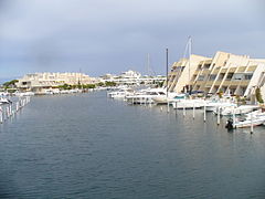 ヨーロッパ最大のヨットハーバー、ポール=カマルグ
 -
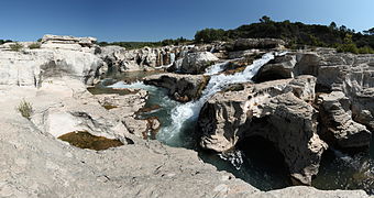 ソータデ滝
ソータデ滝 -
 コスティエール地方のブドウ畑
 -


脚注
- ^ [ http://splaf.free.fr/ "splaf"]
- ^
"Recensement de la population au 1er janvier 2006". Insee.
{{cite web}}: Cite webテンプレートでは|access-date=引数が必須です。 (説明) - ^ "Évolution et structure de la population du département (de 1968 à 2008)". Insee. 2011年7月27日閲覧。
- ^ http://www.insee.fr/fr/themes/tableau.asp?reg_id=1&ref_id=agrtc10201
- ^ “今夏のフランス、熱波関連の死者1435人に 保健省が発表”. CNN (2019-0-09). 2019年9月9日閲覧。
| 全般 | |
|---|---|
| 国立図書館 | |
| 地理 | |
| その他 | |