
利用者:Omotecho/sandbox/アイオワ州の地理


アイオワ州の地理(‐しゅうのちり)とは、アメリカのアイオワ州について地層の分布、地形と水系、地質学や古生物学、都市化の研究を扱う。州の面積は14万5,746 km2 (5万6,272.81平方マイル) である。
地層の分布の特徴
[編集]アイオワ州の地層年代を見ると、一般に西から東へと古くなる傾向がある (図2)。州北西部の地層は白亜紀でおよそ7,400万年前に、東部の岩盤はカンブリア紀で約5億年前にさかのぼる[1]。
流星衝突の構造
[編集]マンソンクレーター
[編集]740万年前、大きな小惑星が現在のポカホンタス郡南東部に衝突し、マンソンクレーターができた。直径はおそらく1.6 km (1マイル) で、デンバーからデトロイトまでの1,050 km (650マイル) 圏内の生物はほぼ死滅したと想像される。従来、恐竜絶滅の原因説があったものの、その後、年代再計算によりクレーターは大量絶滅の約1200万年前に発生したと解析された。惑星衝突の影響を受けた岩盤はアイオワ州に独得で、地表の痕跡は氷河作用によりほぼすべて消えている[2]。
デコラ・クレーター
[編集]
4億7千万年前のオルドビス紀中期に、それよりもはるかに古い小惑星が衝突した跡がデコラ・クレーターで、直径5.6 km (3.5マイル)、地表はウィネシーク頁岩 Winneshiek Shale で覆われる[3][4][5]。この頁岩はアイオワ川上流部の川底から50フィート (15 m)以上深い層にあり、地表に影響はない。衝撃は爆発力換算でTNT火薬1,000メガトンに相当し、地球のマントルこそ貫通しなかったものの、オルドビス紀およびカンブリア紀の岩盤が数100フィート (30 m)押し込まれて凹んでいる[6]。オルドビス紀流星のイベントが4億6900万年前に発生しており、複数の小惑星がほぼ同時に地表に落下したうちの1つである可能性が指摘される[要出典]。
大陸中部の断層
[編集]
アイオワの岩盤の奥深くに埋もれた大陸中部断層構造は、地磁気分布図にはっきりと描出される。カンザス州からスペリオル湖まで広がる10億年前の構造プレートの亀裂であり、地震活動は活発でない[8]。
地震活動
[編集]アイオワには主要な活断層は存在せず、アイオワはラインビルの給水塔が漏出した1968年のイリノイ地震を除き、米国で最も地震については安定した州の1つであり [9]、州内を震源とする地震でこれまで怪我人や重大な被害はなかった。小さな地震は南西部フレモント郡近くで発生し、震源に近いスーシティ周辺は時々、揺れることがある。イリノイ州南部からミズーリ州にわたるニューマドリッド断層を震源とする大地震が発生すると、アイオワ州東部で体に感じることがある[10][11]。オクラホマ州を中心とする2016年の地震はアイオワでも体感したが、被害は出ていない[12]。
化石燃料
[編集]
アイオワ、特にコールビル南部のデモイン川渓谷は重要な石炭産地として古くから開かれ、広域デモイン市の大部分の地域に炭鉱があった。重点地域は時代とともに移り、19世紀はブーンとワトチア (What Cheer) 、20世紀に入ると南部アルビア、センタービル、ルーカス、オスカルーサ周辺の鉱山群が栄える。ただし硫黄含有量が現代の大気汚染基準に対して高い傾向があるため、アイオワ州の商業鉱山は1994年に閉山している[13]。
スー珪岩
[編集]州の西部で観察できる岩盤の年代は一般に若く、例外は北西部のライアン郡にある。狭い地域ながら先カンブリア時代の岩盤が見られ、スー珪岩層と呼ばれる。赤みがかったピンク色の非常に硬い石で、この地方では道路舗装や鉄道敷設にあたり広くスー珪岩を用いる[16]。16.4億年から17.6億年前に堆積したと推定される[17]。

ジオード (晶洞石)
[編集]アイオワ州南東部で産出するジオードは公式に州の岩石の指定を受けた石灰岩の玉石で、色は灰色からピンク色、切断または粉砕すると内部は中空で水晶が析出している。ヘンリー郡ジオード州立公園周辺でよく見られる[18]。
地形と地誌
[編集]

{{Multiple issues|{{More footnotes|section|date=November 2019}} {{One source|section|date=November 2019}}}}
[[Image:Iowa topography.jpg|thumb|250px|left|Topography of Iowa, with counties and major streams]]
[[Image:Landforms of Iowa.jpg|thumb|250px|left|アイオワ州の地形と大小の河川。参考資料:Prior (1991) ならびにカルヴィン (1904)(Calvin)]]
アイオワ州は土地が平坦だと思われがちだが、全域にゆったりとうねる丘が連なる。プライアーの学説[19]によると、この州の地勢は氷河活動、土質、地形と河川系により、8分類される。
漂礫岩平原
[編集]漂礫石(ドリフト)がない特徴から「ドリフトレス」地域とも呼ばれ、深く侵食された岩場が目につく景観が続く。浸食作用を耐えた崖状の岩盤の露頭、深いV字渓谷、洞窟や泉やシンクホールがそこここにある。氷河におおわれなかったため、その痕跡を示す岩石類は皆無もしくはほぼ見つからず、黄土層も薄い。
Copied to translate from en:Geography of Iowa#Landforms and topography &oldid=925888337; and topography, as 23:17 of 12 November 2019 (UTC) by Gwenhope 英語版の翻訳元は左の通り。
===Paleozoic plateau===
Also known as the en:Driftless Area, this region of scenic, high relief landscapes includes such features as resistant, bluff-forming bedrock outcrops, deep V-shaped valleys, caves, springs, and sinkholes. Glacial deposits and en:loess are thin or absent over most of the region.
===Des Moines lobe===

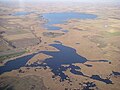
Often called the en:Prairie Pothole Region, the Des Moines Lobe was glaciated up until 12,000 years ago during the en:Wisconsin glaciation. The area is marked by rolling terrain and ridges.[20] Historically, this area was peppered with small interconnected swamps, most of which were drained for farmland. The en:Iowa Great Lakes occur along the western edge of the Des Moines lobe.
===Southern Iowa drift plain===

The southern Iowa drift plain covers most of the southern half of Iowa. This is probably the most familiar landscape to travelers, since most of en:Interstate 80 in Iowa runs through the SIDP. The classic Iowa landscape, consisting of rolling hills of Wisconsin-age loess on Illinoian (or earlier) en:till. The SIDP is some of the most productive agricultural land in the world.
===Mississippi alluvial plain===

Generally level areas of stream terraces, paleochannels, backwater sloughs, and en:oxbow lakes are found within the broad en:Mississippi River valley.
===Loess hills===
The en:Loess Hills consist of very thick deposits of loess in far western Iowa deposited during the Wisconsin and Illinoian periods. Highly eroded, leaving stark, beautiful "golden hills".

===Iowan surface===
Northeast Iowa is covered with eroded Pre-Illinoian till with moderate loess formation, frequently in the form of paha ridges, muted relief except for steep rolling hills near river valleys, and deeper valleys. These picturesque hills are depicted in many of the landscapes of en:Grant Wood.
===Northwest Iowa plains===
Like the Iowan Surface, the Northwest Iowa Plains are rolling hills consisting of eroded soils developed since pre-Wisconsinan glaciation, but with significant amounts of loess.
===Missouri alluvial plain===
Perhaps the only truly flat region of Iowa, the Missouri Alluvial Plain contains areas of terraces, sloughs, and oxbows. Its valley trench is not as deep as the Mississippi River system, and the en:Missouri River is contained in a much narrower channel. In Iowa, the eastern border of the Missouri Plains is the Loess Hills, forming steep rounded bluffs.
デモインの氷河地形
[編集]-
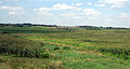
 デモインの氷河地形。湿地帯バリンジャー・スラウ。かつてデモインローブを覆った大草原の名残である。
 -
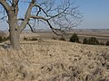
 州南部のどこまでも続く氷河平原の風景。氷河堆積地形の連なりである。
 -
 キングストン北部のミシシッピ川沖積平野。手前は氷河成堆積地形 (SIDP) の崖地
黄土丘陵
[編集]アイオワ土(Iowan surface)
[編集]アイオワ平原の北西部
[編集]ミズーリ川の沖積平野
[編集]水系
[編集]
Copied to translate from en:Geography of Iowa#Water &oldid=925888337; as 23:17 of 12 November 2019 (UTC) by Gwenhope 英語版の翻訳元は左の通り。
==Water==

As in most of the U.S., surface water in Iowa is never safe to drink untreated, contamination by agricultural runoff including en:nitrates, en:herbicides, en:pesticides, and en:animal waste is common, though the en:Clean Water Act has helped. Municipal water supplies are typically heavily chlorinated, this chlorine, combined with high nitrate levels, often give municipal water a strong smell, and the limestone bedrock in much of the state causes hard water.[21] Some communities, such as en:Iowa City resort to additional carbon filtration and en:lime softening coagulation-sedimentation to make the water more palatable.[22] Water treatment can be surprisingly effective; Des Moines' advanced filtration system has led to water quality ranked among the nation's best.[23]
===Jordan Aquifer===
The Jordan Aquifer is the largest source of groundwater, extending from northeast Iowa to south central Iowa, and is ultimately the source of much of Iowa's agricultural and industrial water. In addition to pollution threats, the aquifer is threatened by overuse in well-source irrigation, ethanol production, and the diminishment of resupply caused by extensive field tilling. The aquifer has dropped by as much as 300 feet since the 19th century, resulting in dry wells, the disappearance of natural surface springs, and the diminishment of water quality.[24][25]
ジョルダン帯水層
[編集]土壌
[編集]ラドン
[編集]
Copied to translate from en:Geography of Iowa#Soils &oldid=925888337; as 23:17 of 12 November 2019 (UTC) by Gwenhope 英語版の翻訳元は左の通り。
==Soils==
The NRCS divides Iowa into 23 soil regions. In general, soils of southern, eastern, and western Iowa are loess-derived, while soils of northern and central Iowa are till-derived. Most level areas of Iowa have soils highly suitable for agriculture, making Iowa one of the most productive farming regions of the world.[26]
===Radon===
Like most Upper Midwest and Plains states, en:radon is a common problem in Iowa, especially in areas with clay-rich soils.[27] In Iowa radon is the highest in the southern and the western parts of Iowa
古生物学的な特徴
[編集]デボン紀の化石の渓谷
[編集]ジェファーソン郡は1993年に大規模な洪水が発生し、コーラルビル・レイク・ダム(Coralville Lake Dam)の排水路に沿って河畔の洪水域の表土と川床の堆積物が洗い流され、露出した岩盤からデボン紀の化石がいくつも見つかった。地域は見学施設として整備され河岸の岩盤に降りて見学ができるものの、盗掘が相次ぎ状態の良い化石は取り尽くされている[28]。2008年6月にも大水が出て岩盤の露頭はさらに広がり、また生い茂った植生をも押し流した[29]。
恐竜の化石
[編集]アイオワ州西部にはジュラ紀と白亜紀の地層があり、ネブラスカ州で近似の地層から(くちばしがある)ハドロサウルス科鳥脚類の発掘例があることからも、期待されている。州西部には厚い黄土層が広がるため、化石発掘の機会は鉱業活動もしくは採石場に限られている[30]。
古動物類
[編集]アイオワ州で考古学や古生物学の発掘調査地点からまとまった数の更新世、完新世の古動物の遺物が収集され、それを用いた中西部の古環境再現が行われた[31]。更新世のアメリカ大陸内部の最も早い時期は、アイオワ産の化石を使って自然環境を推定し、1970年代から発掘調査が進むチェロキー先住民居留地の汚水処理場遺跡(Cherokee Sewer Site)の発掘品ほかが活用された[32]。
シェナンドー(Shenandoah)近郊の西ターキオ渓谷(West Tarkio Creek)発掘調査では、地上生活を送った更新世の巨大なナマケモノの仲間を発掘中である。メガロニクス(学名Megalonyx jeffersonii )であることと、成獣1頭、年齢が異なるこども2頭の合計3頭が確認されている。この古生物は通称「ジェファーソンのグラウンド・スロース」と呼ばれる[注釈 1][33][34]。
州出身の著名な地質学者
[編集]Copied to translate from enwp: 12 November 2019 (年11月12日) 23:17 (UTC) 時点における Gwenhope. 左の翻訳元より、節単位の翻訳準備で英語版から転記、英語版内部リンクを:en:で、節題名をnowikiで伏せます。
==Notable Iowa geologists==
Samuel Calvin (1840–1911) was Iowa's first systematic geologist, who helped to make the first bedrock and landform maps of Iowa, as well as lead geological research throughout the state.[35] Calvin Hall at the en:University of Iowa is named for him. en:Clair Cameron Patterson (1922–1995) developed the lead-lead dating and calculated an age for the Earth of 4.55 billion years; a figure far more accurate than those that existed at the time and one that has remained unchanged for over 50 years. en:Charles Rollin Keyes was also an early Iowa geologist who helped map the soils and bedrock of southeast Iowa; he, with Calvin, was a founder of the Iowa Geological Survey.
脚注
[編集]注釈
[編集]- ^ 学名 Megalonyx jeffersonii に折り込まれた「ジェファーソン」とは、かつて大統領を務めたトーマス・ジェファソン(1743年 - 1826年)を指す。ジェファソンは手元にあった化石を1700年代に学識団体に寄付し、これが解剖医キャスパー・ワイスターらの古動物研究に役立てられた。
出典
[編集]- ^ “Prior: Geology of Iowa: Iowa's Earth History Shaped by Ice, Wind, Rivers, and Ancient Seas” (英語). 2009年4月16日時点のオリジナルよりアーカイブ。7 March 2013閲覧。
- ^ “Iowa's Manson Impact Structure” (英語). 2008年6月16日時点のオリジナルよりアーカイブ。7 March 2013閲覧。
- ^ Vastag, Brian (18 February 2013). “Crater found in Iowa points to asteroid break-up 470 million years ago” (英語). Washington Post 19 February 2013閲覧。
- ^ “Geological survey: Ancient meteorite crater sits below Decorah” (英語). Cedar Rapids Gazette. (5 March 2013) 6 March 2013閲覧。
- ^ US Geological Survey. “Iowa Meteorite Crater Confirmed” (英語). 7 March 2013閲覧。
- ^ Iowa Department of Natural Resources. “GEOLOGIC MAPPING FOR WATER QUALITY PROJECTS IN THE UPPER IOWA RIVER WATERSHED” (英語). Technical Information Series No. 54, 2011. 19 February 2013閲覧。[リンク切れ]
- ^ Kucks, Robert P. (2005年). “Iowa magnetic and gravity maps and data” (英語). U.S. Geological Survey. 2009年9月3日閲覧。
- ^ “Midcontinent Rift System In Iowa” (英語). 2007年5月22日時点のオリジナルよりアーカイブ。2008年6月9日閲覧。
- ^ ’’Times-Republican Newspaper’’, Corydon, Iowa, 19 NOV 1968
- ^ “Iowa Earthquake Information”. 2009年5月15日時点のオリジナルよりアーカイブ。2017年8月28日閲覧。
- ^ “Archived copy”. 2009年1月9日時点のオリジナルよりアーカイブ。2017年8月28日閲覧。
- ^ Fickau, Ethan (3 September 2016). “What's the likelihood of feeling another earthquake in Iowa?” (英語). KCCI Des Moines (CBS) 10 September 2016閲覧。
- ^ “Iowa Coal Geology”. 2008年6月15日時点のオリジナルよりアーカイブ。2008年6月9日閲覧。
- ^ State Geologist. “Oil, Gas, and Metallic Mineral Regulatory Information” (英語). アイオワ大学アイオワ地理研究所 Iowa Geological Survey. Iowa Department of Natural Resources. 2008年5月17日時点のオリジナルよりアーカイブ。2008年6月9日閲覧。
- ^ GEOSAM (2008年5月18日). “Iowa oil tests” (英語). web.archive.org. Iowa Geological Survey. 2020年3月2日閲覧。
- ^ “Sioux Quartzite geology” (英語). 2008年7月23日時点のオリジナルよりアーカイブ。2008年6月20日閲覧。
- ^ Wayne I. Anderson, Iowa's Geological Past: Three Billion Years Of Change, University Of Iowa Press, 1998, p.41 ISBN 978-0877456391
- ^ IA DNR: State Parks, Geode State Park
- ^ Prior, Jean C. (1991) Landforms of Iowa. University of Iowa Press, Iowa City. “Archived copy”. 2009年3月2日時点のオリジナルよりアーカイブ。2008年6月9日閲覧。. See also Calvin, Samuel (1904) Outline Map of the Drift Sheets of Iowa. Iowa Publication Co., Davenport.
- ^ “Archived copy”. 2009年3月2日時点のオリジナルよりアーカイブ。2008年6月9日閲覧。
- ^ Iowa City Water Quality Archived May 17, 2008, at the Wayback Machine.
- ^ http://www.icgov.org/default/?id=1623
- ^ 'Drink up - from the city tap.' Des Moines Register 2 July 2008, http://www.desmoinesregister.com/apps/pbcs.dll/article?AID=/20080702/OPINION03/807020346/1110[リンク切れ] Missing on 2018-9-17.
- ^ Love, Orlan (Dec 6, 2009). “Heavy use draining aquifer”. Cedar Rapids Gazette. オリジナルのDecember 9, 2009時点におけるアーカイブ。 20 December 2009閲覧。
- ^ Tecklenburg, Jeff (Dec 18, 2009). “Don’t take aquifer for granted”. Cedar Rapids Gazette. オリジナルのJuly 10, 2012時点におけるアーカイブ。 20 December 2009閲覧。
- ^ Information About Soils | Iowa NRCS
- ^ http://www.extension.iastate.edu/Publications/PM1336.pdf
- ^ Flood of 1993 Archived June 16, 2008, at the Wayback Machine.
- ^ Iowa City Press Citizen, http://www.press-citizen.com/apps/pbcs.dll/article?AID=/20080709/NEWS01/807090324/1079
- ^ Witzke, http://www.igsb.uiowa.edu/Browse/dinosaurs/age_of_dinosaurs_in_iowa.htm Archived 2008-05-11 at the Wayback Machine.
- ^ “Archived copy”. 2008年5月24日時点のオリジナルよりアーカイブ。2008年6月9日閲覧。
- ^ Anderson and Semken (1980) The Cherokee Excavations: Holocene Ecology and Human Adaptations in Northwestern Iowa. Academic Press, New York.
- ^ https://www.sciencedaily.com/releases/2006/06/060626123721.htm, http://slothcentral.com/ Archived 2008-10-08 at the Wayback Machine.
- ^ Semken and Brenzel (2007) One Sloth Becomes Three. Newsletter of the Iowa Archeological Society 57(1).
- ^ Calvin obituary, The Journal of Geology, July 1911, pp. 385-391.
外部リンク
[編集]地質
- オンライン版土壌調査)
- NRCS 土壌調査 (アーカイブ)
- オンライン版土壌調査)
- アイオワ州地質学会 (アーカイブ)
- アイオワ大学
{{plainlist|
- アイオワ州地質調査所
- 地球科学部(アーカイブ)
- アイオワ地質学会年次報告書(IGSAR)
- 石炭資源に関する調査報告書
- 地質写真(サミュエル・カルビン作品集)
- アイオワ州地質調査所
[[Category:アイオワ州の地形]] [[Category:アイオワ州の地理]]